

A Trip To California, 1954
"If you ever plan to motor west,
travel my way, take the highway that's the best.
Get your kicks on Route sixty-six."
Nat King Cole, "Route 66", 1946
United States Highway System in 1954
My family roots are in Arkansas, but they have of necessity spread out all over to go wherever a living could be made. After World War II my father's father, dissatisfied with his lot as a farmer in Yell county, packed the family and headed for California. They settled in Stockton, 60 miles east of the San Francisco Bay. My father, his sister and two brothers remained in, or returned to, Arkansas, which left three brothers, two sisters, and my grandfather in California. That necessitated an annual trip in one direction or the other by one or more members of the family for the next several decades.
It was our turn to go to California in May of 1954.
You may have made a similar trip to visit your relatives. You might have gone east to Pennsylvania, or north to Illinois, or southeast to Florida. No matter which direction you went, however, this is the way it was.
There were no freeways (not even four-lane highways), no city bypasses, no mile markers, no fast-food restaurants. No water bottles (the thermos bottle was used only for coffee). No FM radio -- only AM that hissed and crackled. No transistor radios, no walkmen, no headphones with which to tune out my obnoxious four-year-old sister with whom I had to share the back seat of our 1951 Chevrolet.
There was no air conditioning. Well, we had 4/60 air conditioning -- four windows down and sixty miles an hour. Under those conditions, the windspeed inside the car was such that there was also no magazine or book reading, and no playing card games or board games (Monopoly money would have been all over the highway). "I Spy" was about the extent of our game playing, although at night I liked to play "Cockeye" but my sister did not because I could hit much harder then she.
 There were precious few rest areas, and they were only
picnic tables and trash cans. They had no restrooms, and they were not marked on maps, and there
were no signs telling you how far it was to the next one.
No emergency call boxes or CB radios, and certainly no cell phones.
The only cameras were Kodak boxes, the only film black and white, and the film was
too expensive, so there would be no pictures, only a few post cards collected along the way.
There was no GPS, but we had excellent maps given away free at any service station.
There was no traffic radar, but a policeman could tell a judge you were speeding and the
judge would take his word against yours, and you lost.
There were precious few rest areas, and they were only
picnic tables and trash cans. They had no restrooms, and they were not marked on maps, and there
were no signs telling you how far it was to the next one.
No emergency call boxes or CB radios, and certainly no cell phones.
The only cameras were Kodak boxes, the only film black and white, and the film was
too expensive, so there would be no pictures, only a few post cards collected along the way.
There was no GPS, but we had excellent maps given away free at any service station.
There was no traffic radar, but a policeman could tell a judge you were speeding and the
judge would take his word against yours, and you lost.
The U. S. population was just over 150 million and there were about 40 million cars on the road, most of which were east of the Mississippi. The population is twice that today, and the car count has soared to about 240 million, and they are everywhere. And there were very few trucks, and they were nothing like the gargantuan 18-wheelers that surround you on the road today. In that vernacular, they would have been called ten-wheelers. In 1954, most commerce still moved by rail.
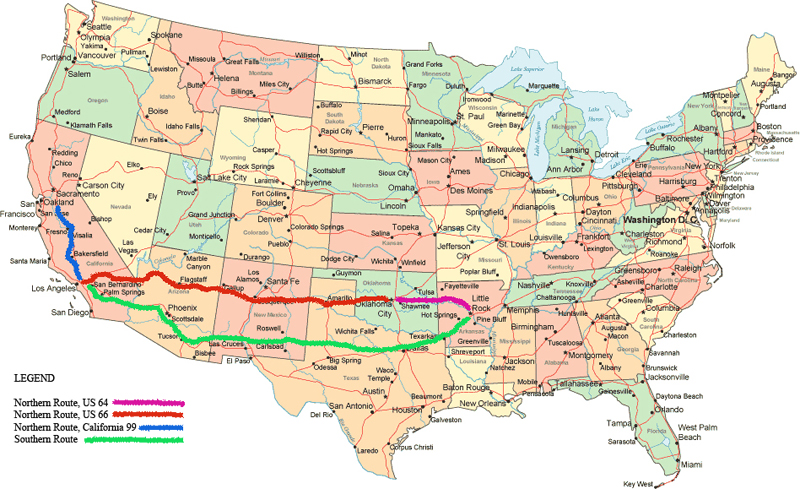
 There were two principal routes to California in 1954 and I've marked them on the map above.
The northern route followed highway 64
from Little Rock to Oklahoma City where we joined Route 66 to Barstow, California.
There, Route 66 continued to Los Angeles, but we took
U.S. 466 (now California 58) to Bakersfield, then California 99 to Stockton.
The southern route followed highway 67 to Dallas, then highway 180 to Phoenix, then north
to Route 66 to Barstow as before. We went to California several times over the years,
and we only took the southern route once, because it was less traveled, and more desolate,
and therefore there were fewer services, and so it offered no advantages other than
visiting relatives in Dallas.
There were two principal routes to California in 1954 and I've marked them on the map above.
The northern route followed highway 64
from Little Rock to Oklahoma City where we joined Route 66 to Barstow, California.
There, Route 66 continued to Los Angeles, but we took
U.S. 466 (now California 58) to Bakersfield, then California 99 to Stockton.
The southern route followed highway 67 to Dallas, then highway 180 to Phoenix, then north
to Route 66 to Barstow as before. We went to California several times over the years,
and we only took the southern route once, because it was less traveled, and more desolate,
and therefore there were fewer services, and so it offered no advantages other than
visiting relatives in Dallas.
In 1954 we took the northern route.
The trip would take the better part of three days. We would make Tucumcari, New Mexico to spend the first night, then Kingman, Arizona for the second. There would be little sight seeing unless we could see it from the road at 60 miles per hour. My father had to take off work for this trip and there would be no income, and lots of outgo, for two weeks. In 1954 he was working in Bauxite making 90 dollars a week, so that would mean the loss of $1,315.00 at todays prices. The lure of family was pretty strong to make my father give that up and make this trip. We would go, but we would not linger anywhere. The goal was to get there and then get back. We were travelers, not tourists.
 Thorough preparation was essential. My father would get the car serviced,
and there would be
a basic tool kit in the trunk. We would have at least one flat going out and another
returning, so we needed a good spare tire, an extra inner tube
(tubeless tires did not gain acceptance until the early 1960s),
a good bumper jack and wheel chocks. We would need a good patch kit, and my father was
a Monkey Grip man. We would
need a water bag to hang on the grille (for both the radiator and for us),
but that was desert-crossing equipment which
we couldn't get in Arkansas. We would pick that up in Oklahoma City as we would need it
when we crossed the Oklahoma-Texas panhandle to Tucumcari.
Thorough preparation was essential. My father would get the car serviced,
and there would be
a basic tool kit in the trunk. We would have at least one flat going out and another
returning, so we needed a good spare tire, an extra inner tube
(tubeless tires did not gain acceptance until the early 1960s),
a good bumper jack and wheel chocks. We would need a good patch kit, and my father was
a Monkey Grip man. We would
need a water bag to hang on the grille (for both the radiator and for us),
but that was desert-crossing equipment which
we couldn't get in Arkansas. We would pick that up in Oklahoma City as we would need it
when we crossed the Oklahoma-Texas panhandle to Tucumcari.
My mother would stock up on groceries for the trip. There was no such thing as a portable cooler (introduced by Coleman later in 1954), so we would have to stop along the way for perishables. We would not eat in many restaurants except for breakfast. Too expensive, but more importantly, took too much time. My father could eat sandwiches while driving and we could be 50 miles down the road in the time it would take us to eat a sit-down lunch. We also packed four empty cola bottles. Along the way we would have to pay two cents deposit each for colas that we took with us, and my father would not fork over the eight cents. If we took the bottles to exchange, we could take our colas and go, otherwise we had to stay where we bought them until we finished drinking them, and that wasted more time.
THE FIRST DAY
Saturday Morning. Daybreak, and we're off.
 It's really an inconvenient time to leave Arkansas because the Arkansas Gazette is running
a "Scrambled Towns" contest. Every day the scrambled
name of a town in Arkansas appears in the paper,
like the one at the right, and I have them all so far. The contest doesn't end for another
week and if I didn't have to go to California I could win a free three-month subscription
to the Arkansas Gazette, worth $4.20. I pull out
the Saturday paper, the last I'll see for two weeks, and unscramble "OIL TROUGH".
It's really an inconvenient time to leave Arkansas because the Arkansas Gazette is running
a "Scrambled Towns" contest. Every day the scrambled
name of a town in Arkansas appears in the paper,
like the one at the right, and I have them all so far. The contest doesn't end for another
week and if I didn't have to go to California I could win a free three-month subscription
to the Arkansas Gazette, worth $4.20. I pull out
the Saturday paper, the last I'll see for two weeks, and unscramble "OIL TROUGH".
That done, it's nap time. I doze until Russellville, then boredom sets in until we make Oklahoma where the trees give way to cattle country and we actually see cowboys on horses riding herd, just like in the movies. There are signs stating that we are crossing the Cherokee Nation. I'm twelve years old, and I wonder if the Indians ever attack the cowboys.

In Oklahoma City we go down a one-way street where the traffic lights are timed for
30 miles per hour, so that if you set your speed at exactly 30 miles per hour you never
have to stop. This is something unseen in Little Rock because this requires
traffic lights with precision timers and they cost more than the dumber, cheaper
traffic lights in Little Rock. Downtown, we leave highway 64 and pick up U. S. 66,
and before we get too far out we stop and buy our canvas desert water bag and hang
it on the front bumper.
 A few miles further we encounter the most successful advertising
campaign in history when we spot our first "Tucumcari Tonight" sign, and that becomes our
anthem, just as it was the anthem for every other traveler on The Mother Road.
A few miles further we encounter the most successful advertising
campaign in history when we spot our first "Tucumcari Tonight" sign, and that becomes our
anthem, just as it was the anthem for every other traveler on The Mother Road.
 Not long afterwards, I spot the first of many examples of the second most
successful advertising campaign in history. I see a "See Rock City" barn. There were
over 900 "See Rock City" barns in the 1950s, and tens of thousands of "See Rock City"
bumper stickers (mainly because cars had bumpers to put them on). I wonder if it has
anything to do with Little Rock. I ask if we're going by Rock City and the answer is,
"No." Rock City
would remain a mystery for another 20 years but by then I learned about
American advertising and I knew to not expect much so I was not disappointed.
Not long afterwards, I spot the first of many examples of the second most
successful advertising campaign in history. I see a "See Rock City" barn. There were
over 900 "See Rock City" barns in the 1950s, and tens of thousands of "See Rock City"
bumper stickers (mainly because cars had bumpers to put them on). I wonder if it has
anything to do with Little Rock. I ask if we're going by Rock City and the answer is,
"No." Rock City
would remain a mystery for another 20 years but by then I learned about
American advertising and I knew to not expect much so I was not disappointed.
Beyond Oklahoma City is mile after mile of prairie. We actually see prairie dogs along the road, just like in that stone-walled compound in back of the monkey house at the Little Rock zoo. It is along this stretch that we encounter two firsts for me. The first is oil fields, with hundreds of wellhead donkeys constantly dipping their noses to the ground. The second is Burma Shave Signs. I had never seen such a clever thing, and I would remember my first one for the rest of my life.
 IF IT'S MUSIC
THAT YOU CRAVE
GET A TUBA
BURMA SHAVE
After my first set of signs, I lived for them for the rest of the trip. They would not disappoint, because there was a set about every 25 miles.
 We cross into Texas and see the first cactus I have ever seen. Not the big
saguaros and Joshua trees
which would come later, but the little prickly pears which are everywhere.
In Amarillo, we are five years ahead of the Big Texan Steak Ranch and its
"free 72 ounce steak", and Cadillac has just begun growing the huge tail fins that
will inspire the Cadillac Ranch in 1974. There is nothing here except the smell of
the world's largest stockyard, which forces us to press on.
We cross into Texas and see the first cactus I have ever seen. Not the big
saguaros and Joshua trees
which would come later, but the little prickly pears which are everywhere.
In Amarillo, we are five years ahead of the Big Texan Steak Ranch and its
"free 72 ounce steak", and Cadillac has just begun growing the huge tail fins that
will inspire the Cadillac Ranch in 1974. There is nothing here except the smell of
the world's largest stockyard, which forces us to press on.
I hate Wheaties, but all year I have been eating Wheaties in anticipation of this trip. In each box there is a miniature state license plate, stamped out of real steel and painted with real enamel, and I have collected them all. I knew the Arkansas, and Oklahoma, and Texas plates, and now I spot my favorite: a New Mexico plate. It is white with red lettering and it depicts the Pueblo sun petroglyph, the Zia (as it does to this day). Before the day ends I will see an Arizona, and if I'm lucky a Nevada, and tomorrow lots of Californias.

Here's our trip, from east (right) to west (left) in license plates
 We make Tucumcari, New Mexico, after dark. Well, I should say after sunset.
It's never dark in Tucumcari because the wall-to-wall neon signs down East Tucumcari
Boulevard run 24 hours a day. We check into a reasonable (cheap) motel. For a treat, we
go to a Mexican restaurant for dinner. The only place we have ever been out to eat
in Little Rock is The Shack Barbecue. We have never been to Browning's
because they don't serve meat and potatoes, my father's diet, so this
is the first Mexican food I have ever eaten.
The chips are tasty, the red stuff is good but it burns my mouth, the tacos are
great, and the green pudding I don't touch. My sister orders a hamburger.
God, she's boring. My stomach growls all night. I can't sleep anyway because a flashing
neon sign is right outside our room and I hear BZZZZZT, BZZZZZT, BZZZZZT until the
motel fills up around 1:00 A. M. and the sign is turned off.
We make Tucumcari, New Mexico, after dark. Well, I should say after sunset.
It's never dark in Tucumcari because the wall-to-wall neon signs down East Tucumcari
Boulevard run 24 hours a day. We check into a reasonable (cheap) motel. For a treat, we
go to a Mexican restaurant for dinner. The only place we have ever been out to eat
in Little Rock is The Shack Barbecue. We have never been to Browning's
because they don't serve meat and potatoes, my father's diet, so this
is the first Mexican food I have ever eaten.
The chips are tasty, the red stuff is good but it burns my mouth, the tacos are
great, and the green pudding I don't touch. My sister orders a hamburger.
God, she's boring. My stomach growls all night. I can't sleep anyway because a flashing
neon sign is right outside our room and I hear BZZZZZT, BZZZZZT, BZZZZZT until the
motel fills up around 1:00 A. M. and the sign is turned off.
THE SECOND DAY
We preceded McDonald's and take-out sausage biscuits, so at daybreak we have breakfast at a legendary Tucumcari greasy spoon for breakfast, because my father can't eat bacon and eggs while driving. I don't remember which legendary greasy spoon (a term that originated on Route 66), and it makes no difference, because all the greasy spoons in Tucumcari in the 1950s were legendary. Breakfast done, we're off.

Just West of Tucumcari, we see our first rocket-powered car. That's what it must be because
it has a rocket engine attached to the side window. Then my father explains that it's
not a rocket engine at all, it's
a swamp cooler. Fill it with water and as you drive along it fills the car with cool
(and highly humidified) air. "Can we have one?" "NO! They cost too much." So that's
two disappointments at once. First, that it's not a rocket engine, and second, that we
can't have one. Actually, I could care less about the cool air. I just think the cars
we see with swamp coolers look, well, cool. That's a Plymouth with a Swamp Cooler
attached to the window at the right.
 The next stop is Cline's Corners, and while my father gets the car serviced we get to
prowl the awesome gift shop.
There are no tee-shirts because we preceded tee-shirts as we know them today.
In 1954 they were called undershirts and
they came only in solid white and you wore them under your shirt and you bought them at
department stores. Regardless, at the age of twelve I am not interested in clothes. I am
interested in life-sized stuffed rattlesnakes,
a necklace you can hang around your neck
with a rattlesnake rattle on it, a belt buckle with a real scorpion mounted in a
glass bulb (today it's plastic, but not in 1954). I can't afford any of this amazing
stuff, but it will fill my dreams, and nightmares, for the next few nights.
We don't tarry. The car is full of gas, we each get an ice cream cone at the cafe
and we're back on the road.
The next stop is Cline's Corners, and while my father gets the car serviced we get to
prowl the awesome gift shop.
There are no tee-shirts because we preceded tee-shirts as we know them today.
In 1954 they were called undershirts and
they came only in solid white and you wore them under your shirt and you bought them at
department stores. Regardless, at the age of twelve I am not interested in clothes. I am
interested in life-sized stuffed rattlesnakes,
a necklace you can hang around your neck
with a rattlesnake rattle on it, a belt buckle with a real scorpion mounted in a
glass bulb (today it's plastic, but not in 1954). I can't afford any of this amazing
stuff, but it will fill my dreams, and nightmares, for the next few nights.
We don't tarry. The car is full of gas, we each get an ice cream cone at the cafe
and we're back on the road.
When we pull into Albuquerque the car is overheating so we'll stop for an early lunch and let the radiator cool down. Everything looks foreign to me. Everything looks Mexicany. Everything smells Mexicany. Over here I smell roasting chilis. Corn tortillas are cooking over there. And everywhere is smoke from pinion fires. Nothing like this back in Arkansas. I am fascinated with it all. I want to eat at another Mexican restaurant. We go to a cafeteria. Cheap eats and lots of meat and potatoes. But this is Albuquerque, and the cafeteria has enchiladas and tamales. Nothing like this at Franke's. Everyone gets what they want.
Leaving Albuquerque the highway climbs steeply for about a thousand feet to the top of a plateau. Looking back to see where we've been, Albuquerque is a small hamlet surrounded by a forest of pinion trees. Today it fills the valley.
In western New Mexico we cross the lava fields near Grants. Miles and miles of lava. I am spellbound. I look for dinosaurs amid the rubble. There are none. Today the lava fields at Grants are no less fascinating to me than they were in 1954, and when I cross them I still look for dinosaurs. It just makes sense that there should be dinosaurs there.
 In the mid-afternoon we pass Thoreau, and not long after that we reach the continental
divide. No one in the car knows exactly what the continental divide is. I had seen Kirk
Douglas and Virginia Mayo in "Along The Great Divide", and I wondered if "great divide"
was the same as "continental divide". We stop for a break at one of the trading posts.
This is better than Clines Corners. There
is all kinds of stuff made of cactus. Cactus lamps of all sizes and styles, and look,
on that counter there, CACTUS CANDY! I had never heard of cactus candy. But if it's
candy it has to be good. And it's pink, and if it's pink, it must taste like red hots,
or at least be cinnamony.
I beg and I plead and
I whine, and my mother buys me a bag of cactus candy on the condition that I share it
with my sister. I say yes, but I'm not about to share it with my sister.
In the mid-afternoon we pass Thoreau, and not long after that we reach the continental
divide. No one in the car knows exactly what the continental divide is. I had seen Kirk
Douglas and Virginia Mayo in "Along The Great Divide", and I wondered if "great divide"
was the same as "continental divide". We stop for a break at one of the trading posts.
This is better than Clines Corners. There
is all kinds of stuff made of cactus. Cactus lamps of all sizes and styles, and look,
on that counter there, CACTUS CANDY! I had never heard of cactus candy. But if it's
candy it has to be good. And it's pink, and if it's pink, it must taste like red hots,
or at least be cinnamony.
I beg and I plead and
I whine, and my mother buys me a bag of cactus candy on the condition that I share it
with my sister. I say yes, but I'm not about to share it with my sister.
 Back on the road my father asks my mother if she asked at the trading post what is the
continental divide and she says no, that she didn't want them to know how ignorant
we all were. Suddenly, there is a sign to enlighten us. We pull over to read it.
Now we are no longer ignorant.
Back on the road my father asks my mother if she asked at the trading post what is the
continental divide and she says no, that she didn't want them to know how ignorant
we all were. Suddenly, there is a sign to enlighten us. We pull over to read it.
Now we are no longer ignorant.
Meanwhile, in the back seat, I tear the cactus candy bag open and pop a piece of cactus candy into my mouth. I tell you this, there is nothing more debilitating to the psyche than to try something new and expect it to be wonderful and have it turn out god-awful, which is what cactus candy is. I try to give the bag to my sister, but she doesn't want it either. She's only four, but she's not stupid, and if I don't want it she knows to pass on it. Rather than throw it out, my mother eats the rest of the stuff, proclaiming all along how good it is because she would never admit to my father that it was a waste of money.
We cross into Arizona, and not long afterward reach our first landmark, the Petrified Forest. I beg to stop, but that is futile. My mother explains that she and my father stopped there once when I was a baby, and they were expecting to see trees, and all they saw was rocks so it wasn't worth the time. My father says we can see rocks in the creek in front of our house on North Taylor Street, and they're free. We also pass the Painted Desert, but I am napping and my mother lets well enough alone. She will answer for that on the return trip because the Painted Desert is something that you can see from the car at 60 miles an hour.
 We drive on. It is not long until we reach Holbrook, home of the Wigwam Motel, where the
rooms are individual concrete Teepees. Next is Winslow, which the Eagles would immortalize
twenty years later in the song, "Take It Easy".
I have no idea why. In 1954 there were a few adobes and no paved
roads in Winslow, and I question the presence of a flat-bed Ford.
It's not all that much different today.
We drive on. It is not long until we reach Holbrook, home of the Wigwam Motel, where the
rooms are individual concrete Teepees. Next is Winslow, which the Eagles would immortalize
twenty years later in the song, "Take It Easy".
I have no idea why. In 1954 there were a few adobes and no paved
roads in Winslow, and I question the presence of a flat-bed Ford.
It's not all that much different today.
Just past Winslow we pass real Teepees on the side of the road. They are every few miles. Outside the Teepees are rows and rows of Indian blankets for sale. Signs tell us that we are in the Navajo Reservation, then the Hopi. I had heard of the Navajo, but not the Hopi. We do not stop. My mother does not like Indian blankets because they scratch your skin. That's because they're made of 100 percent wool. A $2.00 1954 blanket is worth about a thousand bucks today.
Soon, we're just outside of Flagstaff, and we're over 6,000 feet, and we're driving in the snow. Snow is cool if you're a kid in the back seat. Snow is not cool if you're the kid's father trying to drive in the stuff.
We reach Williams and I beg for a side trip up highway 64 to the Grand Canyon. No dice. It's just a big hole in the ground and it's too far off of the main road and we need to make Kingman before the motel rooms fill up. Maybe we can stop on the return trip. "Fat chance," I think to myself. Time would prove me right.

At Peach Springs we stop for gas and I hit the gift shop. There I spot a postcard that
has a picture of a jackalope. It is a huge jack rabbit with antlers. I never knew such
monsters existed. The rabbits back in arkansas were barely bigger than a shoe, and they
certainly didn't have horns. My mother lets me buy the postcard to send to my aunt Ruth
Mae back in Wabbaseka, Arkansas. (That's no joke. My uncle Herman was mayor of Wabbaseka for
years.)
Kingman is not far and we make it in time to get a preferred (cheap) motel room for the night. Arizona cuisine is not haute. In Kingman there aren't even any Mexican restaurants. We end up at a diner where we have the same stuff we could get back in Arkansas. That is, meat and potatoes. Except for trips to California, the only time I have ever heard of Kingman, Arizona, is during the Oklahoma City bombing investigation. Turns out Timothy McVay spent some time in Kingman and set off a few bombs outside the city. In 1954, he wouldn't have had to go far.
THE THIRD DAY
It is not long until we reach the California border. There all traffic is required to stop and be inspected. They ask us if we have any fruits, animals, plants, of any kind. No. No. No. My mother still has some cactus candy left, and I secretly wonder if we should give it to them. In a field off of the road, some people in a pickup are offloading potted plants onto a pile that already contains hundreds of them. And there's a garbage pile that stinks, and my mother explains that it's the confiscated fruit. We are cleared, and a Flat-hatted California Highway Patrol officer waves us on.
 Needles is just across the border in California and is the first stop of the day.
For 150 miles, from Needles to Barstow, we will be in the Mojave Desert,
so it is best to be cautious.
We gas up the car, fill the radiator and water bag, check the tires,
and buy some soda pops to take with us, trading in our empties for the deposit.
On the outskirts of Needles,
a sign at a service station proclaims "Last Chance For Gas next 100 miles",
and they mean it. The next station is 50 miles east of Barstow at Ludlow,
which today is a ghost town bypassed by Interstate 40 and subsequently devastated by earthquakes.
Needles is just across the border in California and is the first stop of the day.
For 150 miles, from Needles to Barstow, we will be in the Mojave Desert,
so it is best to be cautious.
We gas up the car, fill the radiator and water bag, check the tires,
and buy some soda pops to take with us, trading in our empties for the deposit.
On the outskirts of Needles,
a sign at a service station proclaims "Last Chance For Gas next 100 miles",
and they mean it. The next station is 50 miles east of Barstow at Ludlow,
which today is a ghost town bypassed by Interstate 40 and subsequently devastated by earthquakes.
 West of Needles we encounter the phenomenon that I would later anticipate on each trip to
California. Route 66 is built across the Mojave sand dunes for about a hundred miles,
and the roadway undulates like a sine wave. We
drive along for a quarter mile or so, then we dip into an arroyo that might be 50 yards
wide and deeper than our car is tall. We have to be careful during a rainstorm because
it's possible for any of these arroyos to become raging rivers, if only for a few minutes.
But aside from that, as we drive along the desert and see the cars
in the distance ahead of us,
suddenly they disappear. Gone. Nothing. Then a few seconds later they pop up again.
Looking straight down the highway the roadway looks unending and unbroken as if the arroyos
aren't there. We don't see them until we are right up on them. So from a distance when a
car dips into an arroyo, it just disappears for a moment. It is an incredible and unique
optical illusion.
I have never seen such a thing and it keeps me occupied for the next hour, watching
the cars disappear and reappear.
Today, Interstate 40 is flat, and the thrill is gone.
West of Needles we encounter the phenomenon that I would later anticipate on each trip to
California. Route 66 is built across the Mojave sand dunes for about a hundred miles,
and the roadway undulates like a sine wave. We
drive along for a quarter mile or so, then we dip into an arroyo that might be 50 yards
wide and deeper than our car is tall. We have to be careful during a rainstorm because
it's possible for any of these arroyos to become raging rivers, if only for a few minutes.
But aside from that, as we drive along the desert and see the cars
in the distance ahead of us,
suddenly they disappear. Gone. Nothing. Then a few seconds later they pop up again.
Looking straight down the highway the roadway looks unending and unbroken as if the arroyos
aren't there. We don't see them until we are right up on them. So from a distance when a
car dips into an arroyo, it just disappears for a moment. It is an incredible and unique
optical illusion.
I have never seen such a thing and it keeps me occupied for the next hour, watching
the cars disappear and reappear.
Today, Interstate 40 is flat, and the thrill is gone.

In the Mojave, we encounter things that I had only seen in Roy Rogers movies until now.
They are called Joshua Tree Cactus, and to this day they define the desert for me. None
of those little paddle cactus, and not even the saguaros we occasionally encountered back
in Arizona. The Joshua Tree, now that's a real cactus.
The Mojave ends at the Tehachapi range, and the town of Tehachapi sits at the top at an elevation of about 4000 feet. When we reach the western slope of the Tehachapis to begin our descent of 3600 feet into the great San Joaquin Valley, Bakersfield is barely visible about 30 miles in the distance. Between the base of the Tehachapis and Bakersfield is nothing but prairie. Today, the Bakersfield suburbs reach to the Tehachapis and anything that is not residential is farmland and orchards. We stop in Bakersfield to get something to eat -- something portable -- and we decide on barbecue sandwiches. They are so-so. Nothing compares to the gold standard, The Shack in Little Rock.
From Bakersfield to Stockton is boring, uneventful, and mostly after sundown. I catnap, because we will arrive late and then be up until the wee hours of the morning catching up on the family news.
CALIFORNIA
The population of California in 1954 was just over 10 million. Today (December, 2010) it is four times that. We would spend several days over the next week driving around and seeing the sights, and we would have an easy time of it despite our Arkansas license plates. Today, nobody has an easy time driving anywhere in California. But in 1954 we drove all over San Joaquin County and points beyond and seldom encountered traffic of any consequence. Today parts of Stockton are considered bedroom communities of The Bay Area and many people who live there commute as much as 60 miles one way every day.
The San Joaquin Valley is known as "America's Produce Department." There is no doubt why. Even in 1954 evidence of that was everywhere. A drive out the two loops from Stockton is a tour through the produce department of your local grocer.
 First, east on Highway 26 to 160 , then south to Escalon, then west to Manteca,
then back to Stockton. Here you will pass the almond and olive orchards and the two-toned walnut
orchards (English walnuts are native to Central Europe and do not tolerate California
soils, and so are grafted onto darker California native walnut stock.
That's a walnut orchard on the right.) Farther along is mile after
mile of vineyards from the mass-production wineries such as Mogen-David,
then into the lettuce and cabbage fields and the red-speckled bell pepper and Italian
tomato fields.
First, east on Highway 26 to 160 , then south to Escalon, then west to Manteca,
then back to Stockton. Here you will pass the almond and olive orchards and the two-toned walnut
orchards (English walnuts are native to Central Europe and do not tolerate California
soils, and so are grafted onto darker California native walnut stock.
That's a walnut orchard on the right.) Farther along is mile after
mile of vineyards from the mass-production wineries such as Mogen-David,
then into the lettuce and cabbage fields and the red-speckled bell pepper and Italian
tomato fields.
Then, west on Highway 12 to 108 , then south to Antioch, then returning on Highway 4 to Stockton. Here you will pass the cherry orchards, and you will drive through miles of asparagus fields and your car will be covered with the little yellow asparagus butterflies that quickly obliterate your windshield. In 1954, almost everybody smokes, but it is against the law to smoke while crossing the asparagus fields because the base is peat, and a peat fire, which can be extinguished only by flooding the fields with the brackish water from the surrounding sloughs, would devastate the entire area.
On one side trip we visited a winery, where we saw a sight now long gone. Groups of men in rubber hip boots were up in the vats stomping the grapes to release the juice, which flowed from spouts at the bottom of the vats. Today, the stompers have been replaced by machines and today's generation can only see the stompers at festivals and county fairs. But in 1954, that's the way it was routinely done.
 Another day, we went into gold country. East on Highway 4 to Copperopolis,
then south and east to Yosemite Junction, Jamestown, and Sonora. North to the restored
mining town of Columbia where I panned for, and found, real gold, which I carried back home
in a tiny glass vial. Farther on to Angel's Camp, Mark Twain's old stomping grounds, and a side
trip up Highway 104 to Big Trees State Park where we were awestruck by the huge redwoods.
Back to Angel's Camp, then north
to San Andreas and onward to Sutter Creek, the cradle of the 1849 gold rush. Just
north is Amador City, where in 1962 I would take a picture of one of the most
famous street signs in the world, Pig Turd Alley, only to discover that Kodak wouldn't
develop the picture because they deemed it obscene, and in 1962 Kodak and Kodak alone
decided what was and what was not obscene. We returned to Stockton down Highway 104 to Lodi,
which Creedence Clearwater Revival would put on the map in 1969, driving through cotton and bean
fields along the way.
Another day, we went into gold country. East on Highway 4 to Copperopolis,
then south and east to Yosemite Junction, Jamestown, and Sonora. North to the restored
mining town of Columbia where I panned for, and found, real gold, which I carried back home
in a tiny glass vial. Farther on to Angel's Camp, Mark Twain's old stomping grounds, and a side
trip up Highway 104 to Big Trees State Park where we were awestruck by the huge redwoods.
Back to Angel's Camp, then north
to San Andreas and onward to Sutter Creek, the cradle of the 1849 gold rush. Just
north is Amador City, where in 1962 I would take a picture of one of the most
famous street signs in the world, Pig Turd Alley, only to discover that Kodak wouldn't
develop the picture because they deemed it obscene, and in 1962 Kodak and Kodak alone
decided what was and what was not obscene. We returned to Stockton down Highway 104 to Lodi,
which Creedence Clearwater Revival would put on the map in 1969, driving through cotton and bean
fields along the way.
A special treat was spending a few days with my cousins in Hayward, across the bay from San Francisco. We went into "The City" and ate Dungeness crab and walkaway shrimp cocktails on Fisherman's Wharf and swam in the Pacific ocean at Ocean Beach and rode the cable cars for a dime.
 Back in Hayward
I went to a Boy Scout meeting with my
cousin and to get there we had to walk through a cherry orchard and we picked fresh
cherries off of the trees to eat our fill. We preceded BART, and behind my cousin's house
was a railroad track and all day long ran the single car commuter trains
known as Budd Rail Diesel Cars (RDC). I wondered how a railroad car could go down the track
without an engine. That's a Budd RDC on the right.
Back in Hayward
I went to a Boy Scout meeting with my
cousin and to get there we had to walk through a cherry orchard and we picked fresh
cherries off of the trees to eat our fill. We preceded BART, and behind my cousin's house
was a railroad track and all day long ran the single car commuter trains
known as Budd Rail Diesel Cars (RDC). I wondered how a railroad car could go down the track
without an engine. That's a Budd RDC on the right.
HOMEWARD BOUND
We decided to take the time to go home a different route. We headed east out of Manteca and crossed the Yosemite National Park until the road dead-ended at the mysterious Mono Lake. We continued east into Nevada, cut south at Tonopah to Las Vegas (which, in 1954, was still run by organized crime and had a seedy reputation). We continued south, crossed the Boulder Dam, and on into Kingman where we spent the night. There, we hit Route 66 once again and retraced our route back home.
The rest of the trip home was immemorable. I was awake for the painted desert, and was unimpressed. I agreed with my father, "Just colored rocks." I was ready to get home. The thing I remember most, and the thing I would look forward to on every subsequent trip to California, was the appearance in east Oklahoma of the first OAK TREES. I hadn't seen an oak tree in two weeks, and until I saw my first one I didn't even realize I was missing them. Oak Trees meant that we were almost home, and from the time I saw the first one I looked for things familiar with the same enthusiasm I had only two weeks earlier looked for things strange and wonderful.
And that's the way it was in May of 1954.